
 In 1922 the British Empire held sway over about 458 million people, one-fifth of the world’s population at the time.
At its zenith it covered more than a quarter of the Earth’s total land area while its influence spread even further.
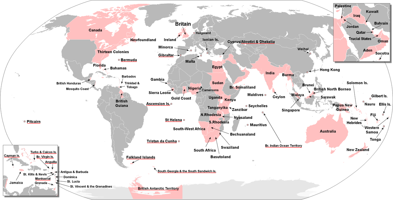
A map of British Empire with the remaining Overeas Territories underlined in red.
While the 1st World War saw the inevitable waning of the Imperial Star it was the coming of the 2nd World War that confirmed the beginning of the end. Despite the eventual victory of Britain and its allies, British prestige suffered an almost irrevocable ‘loss of face’ that inevitably served only to accelerate the decline of the empire.
British India, Britain’s most valuable and populous possession, achieved independence as part of a larger post-war de-colonisation movement in which Britain also granted independence to most of the territories of the British Empire. For many, the political transfer of Hong Kong to China in 1997 marked the final nail in the coffin of Empire.
To this day there remain fourteen British Overseas Territories (B.O.T’s) that remain under the jurisdiction and sovereignty of the United Kingdom whose culture and heritage are still a part of the greater whole and so deserve recognition here.


Caribbean, North Atlantic Ocean

 British Antarctic Territory : Rothera
Antarctica
 British Indian Ocean Territory : Diego Garcia
Indian Ocean
 British Virgin Islands : Road Town
Caribbean, North Atlantic Ocean
 Cayman Islands : Georgetown
Caribbean, North Atlantic Ocean


 Montserrat : (Plymouth) Brades
Caribbean, North Atlantic Ocean
 Pitcairn Island : Adamstown
Pacific Ocean
 Saint Helena : Jamestown
South Atlantic Ocean
 #Tristan da Cuhna
 #Ascension Island
 South Georgia and the South Sandwich Islands : King Edward Point
South Atlantic Ocean
 Turks and Caicos Islands : Cockburn Town
Lucayan Archipelago, North Atlantic Ocean
Although they are parts of the former British Empire that have not chosen independence or have voted to remain British territories, they are mostly self-governing with their own internal leadership, whilst sharing the British monarch (currently Queen Elizabeth II) as head of state.
The name “British Overseas Territory” was introduced by the British Overseas Territories Act 2002, replacing the name British Dependent Territory introduced by the British Nationality Act 1981.
With the exceptions of the British Antarctic Territory, South Georgia and the South Sandwich Islands (which host only officials and research station staff) and the British Indian Ocean Territory (used as a military base), the Territories retain permanent civilian populations. Permanent residency for the 7,000 or so civilians living in the Sovereign Base Areas of Akrotiri and Dhekelia is limited to citizens of the Republic of Cyprus.
Collectively, the Territories encompass a population of approximately 350,000 people and a land area of approximately 667,018 square miles (1,727,570 km2). The vast majority of this, 660,000 square miles (1,700,000 km2), constitutes the British Antarctic Territory. The United Kingdom participates in the Antarctic Treaty System and, as part of a mutual agreement, the British Antarctic Territory is recognised by four of the other sovereign nations making claims to Antarctic territory.

